• Published on

    A Martinsburg Mystery

    Image description
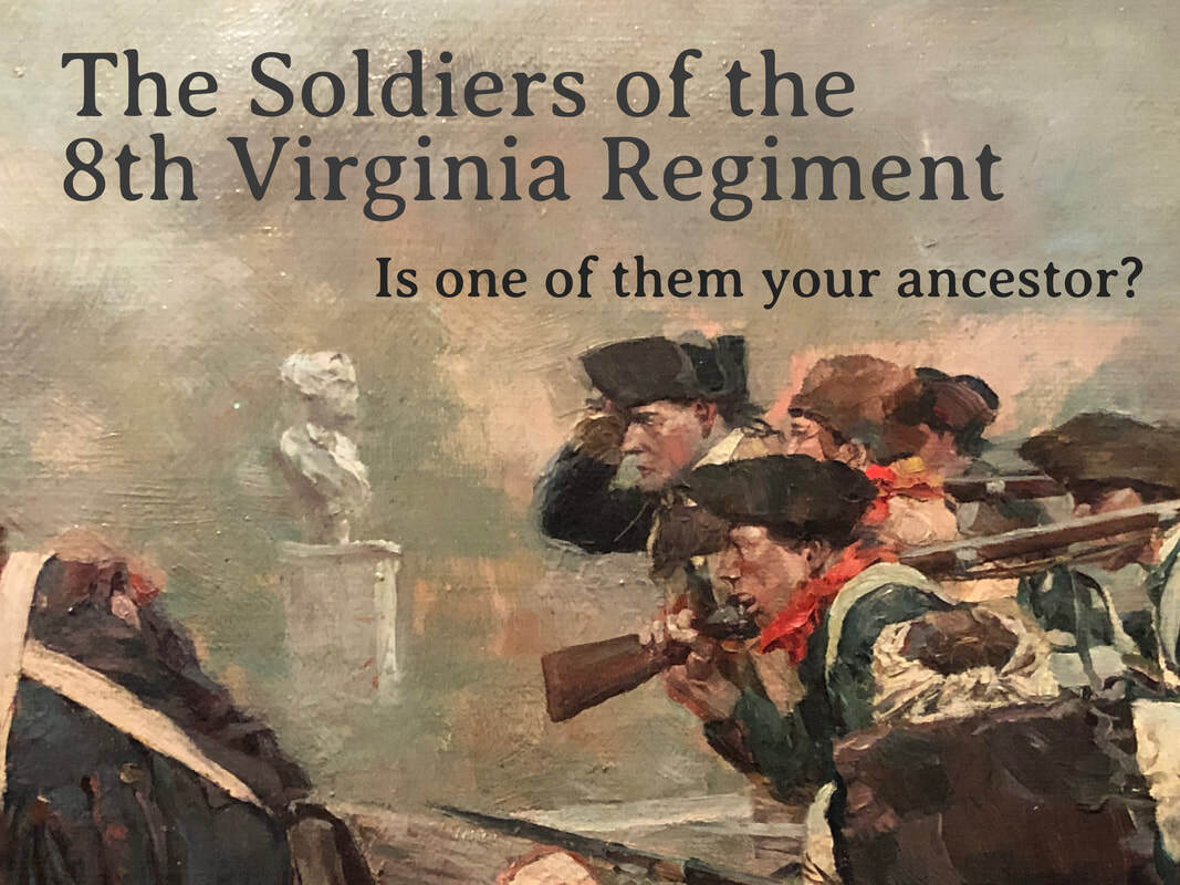
    Maj. Gen. Adam Stephen was the 8th Virginia's division commander in 1777, leading them at the battles of Brandywine and Germantown. He worked closely with George Washington for more than two decades, sometimes challenging and undercutting him. He ran against Washington for the House of Burgesses and almost ruined the surprise Christmas, 1776 attack on Trenton by sending soldiers across the river to settle a personal vendetta against the Hessians. He was reportedly drank too much, and was finally court-martialed and cashiered from the Army after the disaster at Germantown.

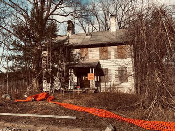
    That did not end his life of civic engagement, though. He founded Martinsburg (now in West Virginia) and served in the Virginia convention that ratified the U.S. Constitution. Sometime during the war, he built a fine house for himself where Martinsburg grew up. Intriguingly, he built his house over the mouth of a cave. According to tradition, this was done to prove an escape in case of an attack by Indians or other enemies. Since that era, the cave has been filled in with dirt, leaving a persistent mystery: where does the natural underground tunnel lead? For nearly twenty years, TriState Grotto--a local caving club--has been working to excavate the passage, one five-gallon bucket at a time. Videos of their progress (and archeological finds) have been posted occasionally on YouTube. Here they are, in chronological order. 

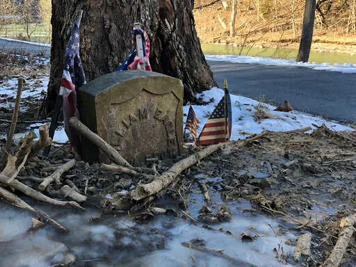
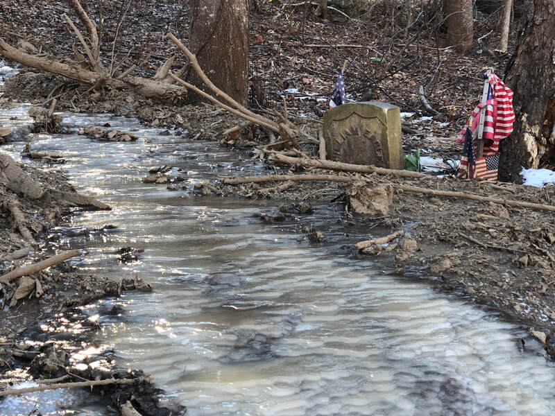
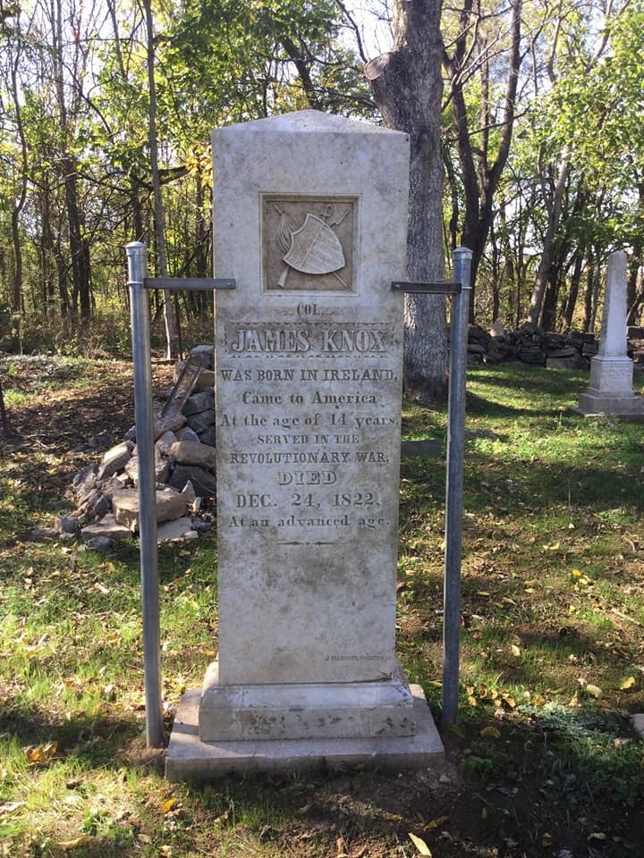
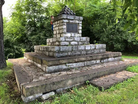
    Stephen died in 1791 and is buried under a rustic monument not far from his home. Despite the controversies associated with his life, he served his country at important moments and in important ways. He was with Washington at Jumonville Glen, Fort Necessity, and Braddock's Defeat years before his Revolutionary War service. His French and Indian War waistcoat and gorget are in the Smithsonian. Aside from his legacy of service and these artifacts, he left an enduring mystery beneath his house. One day soon, perhaps, we'll know where the tunnel leads.

    More from The 8th Virginia Regiment

    Picture
    Picture
    Picture
  • Published on

    The Last Vestige of the Clove Road

    Picture

    The last vestige of the Clove Road runs by Sidman's Tavern, better known today as the Smith House. The road was the Continental Army's critical connection through New York's Ramapo Mountains that kept armies supplied and moving. (Image: Aidan Hand)

    The last remnant of the Continental Army's route through ​New York's Ramapo Mountains may soon be gone.
    With no actionable intelligence, General Washington had to guess where British Maj. Gen. William Howe was taking his army. So in July 1777, he led the Continental Army north from New Jersey into what was then a rough, dangerous, and little-known pass through New York’s Ramapo Mountains. He had guessed incorrectly, however, and they were soon racing south again. Two hundred and forty-two years later, one of the last vestiges of this frantic Revolutionary detour may fall to a bulldozer.
    After wasting much of the spring of 1777 trying to lure Washington’s army out of the Watchung Mountains, General Howe moved his army out of New Jersey and back to Staten Island. The preceding twelve months included the battles of Long Island, Harlem Heights, White Plains, Trenton, Assunpink Creek, Princeton, and Short Hills, but Howe was now literally back where he had begun. Together, the eight battles had earned the British little more than possession of Manhattan.
    In July, Howe’s soldiers began to board ships. This was big news, but not actionable intelligence. Washington needed to know where the enemy planned to go. Howe’s ships could take the Crown troops any place near navigable water. The Continentals, on the other hand, would have to race on foot to meet Howe’s Anglo-German army, planning their first movements on nothing more than an educated guess. This was an extreme disadvantage for the Americans. Washington reported to congressional President John Hancock, “The amazing advantage the Enemy derive from their Ships and the Command of the Water, keeps us in a State of constant perplexity and the most anxious conjecture.”

    Conjecture focused on two primary possibilities: Howe might move up the Hudson River and seize the Hudson Highlands, a strategic choke point on the river next to the site where the United States Military Academy was later built and sixty miles upriver from New York City. With Gen. John Burgoyne’s forces moving south from Canada, this maneuver would complete the British plan of achieving control of the critically important Hudson-Lake Champlain corridor. The other scenario was an attack on Philadelphia, the target Howe had seemed intent on taking through the spring. If the seat of Congress was in fact his target, a landing on the west bank of the Delaware River now seemed most likely.
    Picture

    A revised and expanded version of this essay appears in the 2020 printed volume of the Journal of the American Revolution.

    More from The 8th Virginia Regiment

  • Published on

    Shame in Smoke Hole Canyon

    Image description
    ​I’ve written twice before about Private William Eagle, who enlisted into the 8th Virginia late in 1777 and joined at Valley Forge just before the two-year enlistments of the original men expired. He was evidently just 16 years old. He was the son of very early settlers of Pendleton County, West Virginia’s remote Smoke Hole Canyon and returned there after the war.
     
    He was buried in the beautiful canyon facing a remarkably vertical rock formation that now carries his name: Eagle Rock. Over the years Smoke Hole Canyon became a pocket of Unionism in a region of otherwise intensely pro-Confederate sentiment, a haven for moonshiners, and eventually part of the Monongahela National Forest. His grave, perhaps not permanently marked, was lost for many years until discovered by Forest Service surveyors about 1930 when a new stone was set in the ground.
     
    Photos of the spot on the internet show a pretty and bucolic setting. The stone sits under a sycamore tree and appears well-attended with a crisp and clean American flag. Returning recently from a family vacation, however, I stopped by the site and discovered that it looks nothing like those images. In mid-January the stone was half-buried in frozen debris at the end of a virtual river of ice descending from the ridge of North Fork Mountain. The base of the sycamore’s trunk is rotting. It looks as though an impromptu hiking trail has become a path for water runoff. On a 20-degree day following two days of rain, Private Eagle’s grave was covered by forest debris that had washed down the mountain. Attempts to clear it were fruitless. It was frozen solid.
     
    Perhaps this is a purely seasonal phenomenon, but a Revolutionary War veteran’s grave deserves better care. It appears to me that thoughtless hikers are the culprits. Someone—the Forest Service, Pendleton County, neighbors, a Boy Scout looking for an Eagle Scout project, the DAR or the SAR—should find a way to protect the grave from what seems like inevitable serious damage.
    Frozen runoff covers William Eagle's grave.
    The words "8 VA. REGT." are just visible on the grave stone.
    The view of Eagle Rock from the gravesite. The dates on the historic marker are wrong.
    A river of ice follows what may be a hiking trail from the top of the mountain.
    Ice, debris, and torn and dirty flags surround the grave.
    An undated photograph of the grave in better condition.
  • Published on

    Searching for Captain Knox

    Picture
    ​We only know the history that is written down. Some of the 8th Virginia’s most valiant warriors left sparse records and have consequently been forgotten. One of the best parts of this project is the opportunity to bring some of their stories back to life. A case in point is the story of Captain James Knox.

    It has long been believed that Knox used his inheritance to come to Virginia from Northern Ireland at the age of 14. Period records seem to indicate he was born in Virgina, so it may have been his father who came that way. Regardless, Knox lived an amazing life. He evidently entered Kentucky through the Cumberland Gap before Daniel Boone did. He was the leader of the famous “long hunts” into Kentucky in 1769, 1770 and 1771 before serving in Dunmore’s War against the Shawnee in 1774. 
    He then led the Fincastle (Kentucky) County company for the 8th Virginia in 1776. After his company was decimated by malaria in south, he was detached to lead a new company in Morgan’s Rifles and took part in the first major American victory of the war at Saratoga. After the war, he served in the legislatures of Virginia and Kentucky (after it separated from Virginia) and served in the Kentucky militia as a colonel. In 1805 he married the widow of his neighbor and friend, Benjamin Logan.
    Knox died on Christmas Eve in 1822 and was buried near his wife and Logan. From there, this once-prominent frontier hero slowly slipped into obscurity. In 1923, a Kentucky historian reported that Knox’s gravestone had “fallen from its base to the earth” where it lay “forgotten” in a “neglected and overgrown” graveyard. In 1964, the Commonwealth of Kentucky placed a historic marker two miles away on the Louisville Pike (Route 60). One side memorialized Benjamin Logan, the other (the back, officially) memorialized Knox.

    On a recent trip to Kentucky, I decided to find the marker and—if I could—Knox’s grave. The Kentucky Historical Marker Database said the Logan-Knox sign was four miles west of Shelbyville. I drove ten miles west of Shelbyville, but couldn’t find it. An internet search found a newspaper account of the 2015 rededication of the Logan family burial ground (where Knox is buried), with vague directions. I thought, perhaps, the sign had been moved there—somewhere on Brunerstown Road.
    Picture

    James Knox's grave. (Courtesy of Mike Harrod)

    Picture

    The grave of Ann Logan Allen, just visible through the trees, high up on a bluff over the Bullskin Creek. This photo was taken with an iPhone at maximum zoom.

    [In 2020, Mike Harrod informed me that the marker visible from the road actually belongs to Logan's daughter, Ann Logan Allen.]

    ​Driving south from Shelbyville, Brunerstown Road was easy to find and the sign was right there at the intersection. Though happy to find it, I was disappointed to see it was literally posted in a ditch. Worse, it was falling over and situated so that the only way to read Knox’s side was to get out of your car and walk into the field behind it. After taking several photographs, I drove the length of Brunerstown Road looking for the cemetery but couldn’t find it. 

    After a mile, the road narrowed and lost its markings—looking, probably, just the way it had in Knox’s day but for the pavement. On my second pass, I encountered a man checking his mail box. He happily told me where the graveyard was—up on a hill overlooking the Bullskin Creek. Far from the road, it was inaccessible except through a neighbor’s property, and they were not home.
    I drove by the creek one more time and looked high up on the bluff on the opposite side. Through the trees, I could just make out a monument. Looking on my phone at pictures on FindAGrave.com, I decided it looked like Benjamin Logan’s grave marker. Knox’s grave is up there too, but can’t be seen from the road. 
    The Logan cemetery was cleaned up in 2015. Already “neglected and overgrown” in 1923, it was described in 2015 as “in complete disrepair; you couldn’t even walk through it, you had to spread the trees and the bushes and the vines apart to even get through it.” My search for Knox’s grave is a perfect allegory for the story of the 8th Virginia. The story is out there, but it’s frequently very hard to find.

    ​Read More: ​"James Knox Was There Before Daniel Boone" (8/19/17)

    (Updated 1/27/21)
    8th Virginia Captain James Knox was among the very first European Americans to explore Kentucky through the Cumberland Gap, possibly before Daniel Boone. (Author)
    The Logan-Knox marker has been relocated to the intersection of Taylorsville Road and Brunerstown Road, south of Shelbyville, Kentucky. It is leaning over in a ditch, with the Knox-side of the sign not visible from either intersecting road. (Author)
    The grave of Benjamin Logan. (Courtesy Mike Harrod)

    More from The 8th Virginia Regiment

  • Published on

    Locust Grove and the 8th Virginia Regiment

    Image description

    No other place does more to tell the story of the 8th Virginia Regiment than the house and museum at Locust Grove, near Louisville, Kentucky. It does this almost unintentionally. Locust Grove was the after-war home of Captain William Croghan (who was a major when the war ended). He married the sister of fellow 8th Virginia Captain Jonathan Clark and lived not far from Clark at the fall-line of the Ohio River (Louisville). This was a roughly 400-mile boat ride from his old home at Pittsburgh.For many 8th Virginia men, the opening up of Kentucky was their main reason for fighting in the war. Colonel Abraham Bowman, captains Croghan, Clark, James Knox, and George Slaughter all moved to Kentucky after (or during) the war. So did a large number of the regiment’s junior officers and enlisted men.

    I have compared this research to a jigsaw puzzle—the compilation of thousands of discrete bits of information from a multitude of sources. It was a bit of a shock, therefore to visit Locust Grove and find a place that seemed in so many ways to be a memorial to the 8th Virginia Regiment and its veterans. It isn’t actually that, of course. I don't think the regiment itself is even mentioned. Much more is said about Croghan's brother-in-law George Rogers Clark. But the museum’s exhibits wonderfully contextualize and illustrate the world of the 8th Virginia, before, during and especially after the war.

    Croghan was a very important man in Kentucky. He had money, land, and relationships. Much or most of that—including his marriage—came to him through his service in the war. The same could be said for many of his 8th Virginia comrades who prospered in the west. It was in large measure what they fought for during the Revolution: opportunity.
    Picture

    Portraits of the elderly Lucy and William Croghan hang inside the house.

    Picture
    Picture

    Through his wife, Croghan was related to explorer William Clark and General George Rogers Clark.

  • Published on

    James Knox Was There Before Daniel Boone

    Image description
    ​The adventures of 8th Virginia Captain James Knox have been unfairly overshadowed by those of Daniel Boone. This may be true generally, but it is definitely—and literally—true at the site of a memorial marker in Greene County, Kentucky.
     
    The 8th Virginia’s recruitment area was vast—covering almost the entire Virginia frontier, which at that time stretched from Pittsburgh to the Cumberland Gap—a distance of 450 miles. Those two places were, at that time, the only practical access points to the “Kentucky Country”—all of which was, at the start of the war, part of Fincastle County, Virginia. To get there, you could float down the Ohio River from Pittsburgh, or you could travel overland through the Cumberland Gap. Few had taken the latter route, however, when James Knox led a hunting party that way in 1770.
     
    Knox was one of the original “Long Hunters,” who entered Kentucky on months-long or even years-long hunting trips, intending to return with large quantities of pelts. Daniel Boone is by far the most famous of the long hunters, but that is partly because there is only room for one of these little-remembered adventurers in public memory.
     
    In 1770, James Knox and his team established a hunting camp and pelt repository (a “skin house”)  by the north bank of a creek now known as Skinhouse Branch. Years later, a church was built on the same site. Today, the 187-year old nondenominational church sits at the intersection of Skinhouse Branch and Long Hunters Camp roads—neither of which carries enough traffic to warrant painted markings. It is surrounded by farms growing corn, tobacco, and soybeans. Two stone markers were put there long ago by local citizens to memorialize James Knox and the hunting expedition of 1770. In front of them, and closer to the road, is an official Kentucky state historic marker noting that Daniel Boone was also there—a year later.
     
    Early in 1776, Knox recruited one of the 8th Virginia’s ten companies. His men were decimated by malaria during the South Carolina expedition of that summer and fall. By the spring of 1777, only a handful were left. Knox became a captain in Morgan’s Rifles and commanded a company at the victory at Saratoga. He took a few of his 8th Virginia men with him, and his 8th Virginia Regiment company ceased to exist. He was a prominent citizen of Kentucky in his later years, but has always been overshadowed by Daniel Boone.

    Read More: "Searching for Captain Knox" (3/29/18)
    Picture

    The Knox monument is upstaged by a marker celebrating Daniel Boone's presence at Camp Knox a year later.

    Picture

    Knox's hunting companions are listed under a header that was probably intended to say "The Names of the Long Hunters."